TL;DR
- Key takeaway: The “best” biker road in America depends entirely on your skill level, bike type, and what you actually want from a ride — not what YouTube thumbnails tell you.
- Best for canyon carving: Tail of the Dragon (US-129), NC/TN
- Best for epic scenery with lower risk: Going-to-the-Sun Road, MT
- Best for long-haul touring: Blue Ridge Parkway, VA/NC
- Best for desert riding: Highway 89A through Sedona, AZ
- Best kept secret: The Loneliest Road in America (US-50), NV
- Counterintuitive insight: The most famous road on this list — Tail of the Dragon — has one of the highest crash rates per mile of any road in the country. Beginners who show up because they saw it on a biker forum often leave on a flatbed.
You’ve spent months planning a riding trip across the USA. You’ve watched every “best motorcycle roads” video on YouTube, bookmarked three different forums, and now you’re staring at a map that looks like a plate of spaghetti. Every article says the same five roads. Every list has the same generic blurb about “sweeping curves” and “breathtaking views.”
What none of them tell you is which road will actually match your riding style, your bike, and the time of year you’re going. They don’t tell you about the gravel that washes across the Dragon after a rainstorm. They don’t mention that Going-to-the-Sun Road is closed to bikes over a certain length. Nobody warns you that the Blue Ridge Parkway has a 45 mph speed limit enforced by rangers who have absolutely nothing else to do.
I’ve ridden all five of these roads. Some of them more than once. And I’ve made enough mistakes — and talked to enough other riders who made worse ones — to give you something more useful than a list.
How I Evaluated This
Before we get into the roads themselves, let me be transparent about what went into this ranking.
My criteria:
- Ride quality: Surface condition, curve variety, sightlines, and how forgiving the road is when you make a mistake
- Scenery-to-risk ratio: A road that kills you before you see the view is not a great road
- Accessibility: Parking, fuel stops, cell service, and what happens if something goes wrong
- Seasonal windows: Some roads are only rideable 4–5 months a year
- Bike compatibility: Not every road suits every machine
What I excluded and why:
I deliberately left out roads that show up on every generic list but have serious practical problems — like PCH (Pacific Coast Highway), which sounds great until you’re stuck in Malibu traffic behind a Winnebago doing 25 mph in a 55 zone. I also excluded roads that are technically beautiful but require permits, restricted access, or are inside private land corridors that change seasonally.
The mistake most riders make:
They optimize for Instagram, not for riding. They pick the road that photographs best, not the one that actually delivers the most satisfying hours in the saddle. Dramatic landscape and great motorcycling are not the same thing.
Road 1: Tail of the Dragon — US-129, North Carolina/Tennessee
This Road Will Either Make You or Humble You
318 curves in 11 miles. That’s the number that gets quoted in every article, and it’s the number that gets people hurt.
The Dragon — formally US-129 between Deals Gap, NC, and Chilhowee, TN — is arguably the most famous motorcycle road in America. It deserves that reputation. The corners come fast, they stack on top of each other, and there is almost no margin for error. Guardrails are minimal. The edge of the pavement drops off in ways that don’t care about your insurance policy.
I first rode the Dragon on a Street Triple 765 on a Tuesday in October. Almost no traffic, cool temps, dry asphalt. It was one of the best 25 minutes of riding I’ve ever had. I came back the following July on a Saturday, and it was a completely different experience — bikes everywhere, a handful of people who had clearly never ridden this kind of road, and a tow truck sitting in a lay-by like it was waiting for business. Which it was.
Who it’s best for:
- Experienced riders on sport or sport-touring bikes
- Anyone who has done track days and knows their limits
- Riders who can read a corner before they’re already in it
Who should avoid it:
- New riders (under 2 years of consistent experience)
- Anyone on a heavy touring bike over 700 lbs
- Riders who rely on their brakes as a primary input — the Dragon punishes late brakers hard
Real-world constraint: The road has a “Tree of Shame” near the gap where locals hang pieces of crashed bikes. It’s funny until you realize how many of those pieces came from riders who thought they were ready. Cell service is nearly nonexistent. The nearest hospital is 30+ miles away.
Pros:
- Technically unmatched in the eastern US
- Relatively short, so you can do multiple passes
- Strong riding community in the area (Deals Gap Resort is a legitimate hub)
Cons:
- Summer weekends are chaotic
- Gravel and debris after rain
- Zero room for error on blind crests
Best time to ride: Mid-week in September or October. The leaves are turning, the temps are manageable, and the crowds thin out dramatically.
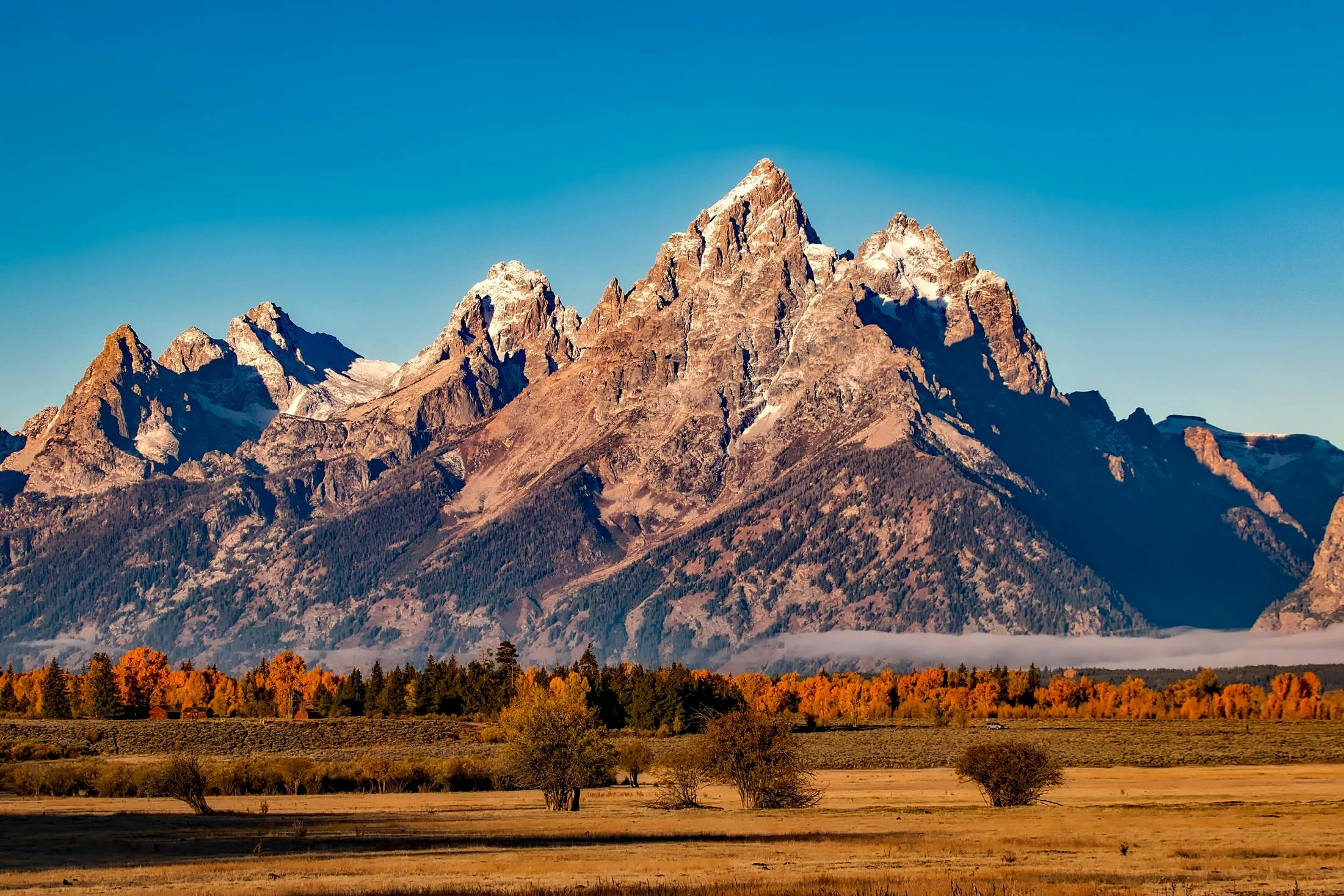
Road 2: Going-to-the-Sun Road — Glacier National Park, Montana
The Most Spectacular Road in America Has a Catch Most Bikers Don’t Know About
Going-to-the-Sun Road crosses the Continental Divide through Glacier National Park — 50 miles of road that climbs to 6,646 feet at Logan Pass. It is, without exaggeration, one of the most visually striking roads on earth. Glaciers on your left. Thousand-foot drops on your right. Waterfalls crossing the road directly in front of you.
Here’s what most articles skip: motorcycles over a certain length are restricted. As of recent seasons, vehicles over 21 feet in length (including trailers) are prohibited between Avalanche Creek and the Sun Point parking area during peak season. That’s not a problem for most bikes, but if you’re pulling a trailer or riding a stretched touring rig, you need to check current NPS regulations before you show up. They will turn you around.
The road is also only fully open for a narrow window — typically mid-June through mid-October, depending on snowpack. I’ve been up there in early July when rangers were still using snowplows on the upper sections. The views were spectacular. My hands were numb.
Who it’s best for:
- Touring riders who want scenery over technical challenge
- Photographers and riders who stop every 10 minutes (there are enough pullouts)
- Anyone on a first visit to Montana who wants the full experience
Who should avoid it:
- Riders who hate crowds — the road gets genuinely congested in July and August
- Anyone uncomfortable with sheer drop-offs on one side and no guardrails
- Riders looking for technical challenge — the road is relatively straightforward, which is exactly the point
Real-world constraint: The park now uses a timed-entry permit system during peak season. You need to book in advance. Showing up without a reservation in July will get you turned away at the entrance. The NPS website has current info, and it changes year to year.
Pros:
- Unmatched scenery in the continental US
- Well-maintained road surface
- Fuel and facilities available at both ends
Cons:
- Short riding window
- Permit requirements add planning complexity
- Not a technical road — pure touring, minimal excitement
Best time to ride: Early September, weekday morning. Most summer tourists are gone, the light is golden, and Logan Pass is still open.
Road 3: Blue Ridge Parkway — Virginia to North Carolina
469 Miles of the Most Consistent Riding You’ll Find Anywhere
The Blue Ridge Parkway runs 469 miles from Shenandoah National Park in Virginia down to the Smoky Mountains in North Carolina. It was built specifically for leisure driving, which means it was designed with flow in mind — gradual elevation changes, smooth curves, and a pace that rewards riders who aren’t in a hurry.
This is the road I’d recommend to more people than any other on this list. Not because it’s the most thrilling, but because it delivers sustained, consistent quality across a massive distance. You can ride a week on the Parkway and not run out of new sections to explore.
The 45 mph speed limit is real, and rangers do patrol it. If you’re the kind of rider who treats any speed limit as a suggestion, you’ll get a ticket here. But if you’re willing to settle into the pace, the road opens up in a way that faster riding actually misses. You start noticing the layers of ridge lines, the fog sitting in the valleys, the way the light changes through the tree canopy.
Who it’s best for:
- Long-distance tourers
- Riders on cruisers and standard bikes
- Anyone riding two-up or with luggage
Who should avoid it:
- Sport bike riders who need technical challenge to stay engaged
- Anyone on a tight schedule (no direct routes — the Parkway is the destination)
Real-world constraint: Fuel is not available on the Parkway itself. There are gaps in the road, and some sections close seasonally. You need to plan fuel stops carefully — some segments go 60+ miles without a station at a nearby exit.
Pros:
- Accessible entry points along the full length
- Campgrounds, lodges, and visitor centers throughout
- Manageable for almost every skill level
Cons:
- Speed limits are strictly enforced
- Can get crowded during fall foliage (late October)
- Some sections have rough pavement or construction delays
Best time to ride: Mid-May for wildflowers, or the last week of October for peak fall color. Avoid holiday weekends.
Road 4: Highway 89A Through Sedona — Arizona
The Desert Ride That Changes Your Perception of Color
Most desert riding gets written off as boring — long straights, flat terrain, nothing to look at. Highway 89A through Sedona and Oak Creek Canyon blows that assumption apart completely.
The route runs from Sedona north through Oak Creek Canyon, climbing 2,000 feet in about 14 miles. Red rock formations the color of dried blood. Cottonwood trees that go bright gold in autumn. The canyon walls close in around you and then open back up into the high country around Flagstaff.
I’ve ridden this road in late October, and the combination of the red rock against fall foliage is something that doesn’t fully register as real. It looks like a film set.
The southern approach through Sedona itself is worth mentioning separately. The strip through town is congested with tourist traffic and pink jeep tour vehicles, but once you get north of town on 89A, the road earns its reputation fast.
Who it’s best for:
- Riders who want dramatic scenery with moderate technical demand
- Anyone combining a ride with broader Southwest touring
- Winter and early spring riders — this road is accessible year-round
Who should avoid it:
- Riders expecting long uninterrupted stretches — Sedona town traffic is real
- Anyone sensitive to heat — summer temps in Sedona regularly top 100°F
Real-world constraint: Parking and stopping in Sedona now requires a Red Rock Pass or America the Beautiful annual pass. This applies to most pullouts and trailheads. Rangers check. Budget $20–$30 per day if you don’t have an annual pass.
Pros:
- Year-round riding window
- Visually unlike anything else in the country
- Strong riding infrastructure in Flagstaff at the top
Cons:
- Town congestion in Sedona
- Heat management in summer is serious business
- The canyon section is relatively short (14 miles)
Best time to ride: Late October or early November for fall color at the canyon’s upper elevations. March and April also excellent.
Road 5: US-50 — The Loneliest Road in America, Nevada
287 Miles of Nothing. That’s Exactly the Point.
In 1986, Life magazine called US-50 across Nevada “the loneliest road in America” and advised people not to drive it without survival skills. Nevada leaned into it, created a passport program for riders who completed the route, and turned an honest warning into a marketing campaign.
The road lives up to both the warning and the mythology.
US-50 cuts across central Nevada from Fernley (east of Reno) to the Utah border — 287 miles of open desert with five small towns spaced between 50 and 100 miles apart. The road crosses seven mountain ranges and drops into basins that feel like the surface of another planet. There’s almost no traffic. Cell service disappears for long stretches. The silence is complete enough that you can hear your own engine echo off the mountain walls.
I’ve ridden US-50 solo and with a group. Solo is the right way to do it. The road asks something of you — a degree of self-reliance and presence — that gets diluted when you’re riding in formation with five other people.
Who it’s best for:
- Experienced long-distance riders comfortable with isolation
- Anyone on a well-maintained, reliable bike
- Riders who find crowded roads exhausting
Who should avoid it:
- Newer riders who haven’t done isolated touring before
- Anyone on a bike with fuel economy under 35 mpg (fuel gaps are serious)
- Riders who don’t carry basic mechanical tools and know how to use them
Real-world constraint: Some towns have seasonal hours at their gas stations. Eureka, NV is the midpoint and is reliably open. Austin, NV is small and fuel availability can be inconsistent outside of daylight hours. Carry a reserve.
Pros:
- Genuinely unique experience — no other road in the lower 48 feels like this
- Nevada passport program gives the route a loose structure
- Almost no law enforcement presence
Cons:
- Breakdown in a remote section is a serious problem
- Very limited food and lodging options
- Some riders find the solitude oppressive rather than liberating
Best time to ride: May–June or September–October. Summer heat in the basins regularly exceeds 105°F. Spring can bring snow at elevation.
The Comparison You Actually Need
| Road | Difficulty | Scenery | Crowds | Bike Type | Seasonal Window |
|---|---|---|---|---|---|
| Tail of the Dragon | High | Moderate | High (weekends) | Sport/Naked | Spring–Fall |
| Going-to-the-Sun | Low | Exceptional | High (summer) | Any under 21ft | June–October |
| Blue Ridge Parkway | Low–Moderate | High | Moderate | Any | March–November |
| Hwy 89A Sedona | Moderate | Exceptional | Moderate | Any | Year-round |
| US-50 Nevada | Low (isolation risk) | High (unique) | Very Low | Reliable tourer | May–Oct |
The Mistake Riders Make Planning These Trips
The single biggest error I see — and I’ve made it myself — is stringing multiple “best roads” together into a single trip without accounting for the distance between them.
The Dragon and the Blue Ridge Parkway are relatively close. But if you’re thinking about hitting Glacier and Sedona on the same two-week trip, you’re looking at serious interstate miles in between. Those miles are not nothing. Highway fatigue is real, and showing up to a technical road like the Dragon after eight hours of I-40 is a recipe for a bad decision at 60 mph.
Build in recovery days. Build in mileage days that aren’t supposed to be interesting. The best riding trips I’ve done have a shape: a slow start, a peak in the middle, a deliberate wind-down. Not five consecutive maximum-experience days.
Which Road Should You Actually Ride First?
If you’ve ridden for fewer than three years or you’re on a bike over 600 lbs: start with the Blue Ridge Parkway. It’s forgiving, it’s long, it’s beautiful, and it gives you a genuine feel for sustained mountain riding without the consequences of a road like the Dragon.
If you’re an experienced rider who wants the single most technically satisfying day of riding in the eastern US: the Dragon, mid-week, September, after a dry week.
If you want the ride that will stay with you longest and change how you think about what motorcycling actually is: US-50 across Nevada. It’s not the most dramatic road on this list. It’s not the most technical. But there’s something that happens to a rider somewhere around mile 150 of absolute silence and open sky that none of the other roads deliver. You either get it or you don’t.
The Dragon will test your skill. US-50 will test your character. Pick the one you actually need right now.