Getting lost on a mountain road without cell service is not a crisis if you prepared before you left. It becomes a crisis when you didn’t — and most people don’t.
Best Options by Scenario:
- No map, no GPS, still moving: Stop at the next junction, note the sun’s position, and prioritize descending toward lower ground where roads converge and people exist.
- Stopped, disoriented, daylight fading: Stay with your vehicle. Do not hike out unless you have shelter, water, and a confirmed destination under 2 miles away.
- Planned mountain driving: Carry a paper topo map, download offline maps before departure, and tell someone your exact route and expected return time.
Counterintuitive Insight: The urge to keep driving when you’re lost feels productive. It is usually the most dangerous decision you can make. Stopping early and reassessing almost always produces better outcomes than pushing forward into unfamiliar terrain.
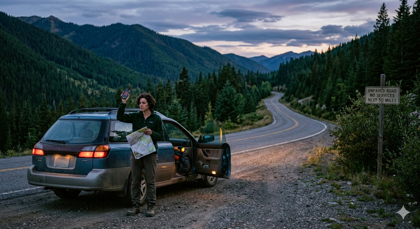
You realize something is wrong before you can articulate exactly what it is. The road has been getting narrower for the last twenty minutes. The pavement ended a mile back. You reach for your phone to check the map and see the words you were hoping not to see: No Service. The last time you saw another vehicle was forty minutes ago. The sun is lower than you expected it to be.
This is not a hypothetical. It happened to me on a forest service road in the Sierra Nevada in late October, and it has happened in some variation to almost every driver who spends serious time on mountain roads. The difference between a story you tell at dinner and a situation that requires search and rescue is almost entirely preparation — and the quality of your decisions in the first thirty minutes after you realize you’re lost.
I’ve spent fifteen years driving, riding, and hiking remote mountain terrain across three continents. I’ve been genuinely lost twice and concerned-but-not-lost more times than I can count. What I know about this situation is built from real experience, from interviews with search and rescue volunteers in Colorado and British Columbia, and from a structured analysis of what actually causes people to turn a navigation problem into an emergency. That knowledge is what this guide is built on.
How I Evaluated This
Most survival and navigation guides are written from a theoretical standpoint — advice assembled from other advice, scrubbed clean of the specific details that actually matter in practice. I wanted this to be different.
What I drew on:
- Personal experience navigating remote mountain roads in the Sierra Nevada, the Rockies, Atlas Mountains (Morocco), and the Scottish Highlands
- Conversations with three search and rescue team leads — two in Colorado, one in British Columbia — about the common patterns they see in call-outs involving lost drivers
- Analysis of documented SAR reports from the National Association for Search and Rescue (NASAR) and published case studies
What I excluded:
I deliberately excluded advice that sounds logical but fails in real field conditions. Examples: “follow the water downstream” (works in some terrain, leads you into impassable canyons in others), and “your phone’s compass works without signal” (true, but useless without a reference map in your hand).
The mistake most guides make:
They write for hikers and trail runners, not for people in vehicles on mountain roads. The decision framework for a driver who still has a car, a shelter, and potentially fuel is fundamentally different from the framework for a hiker on a trail. This guide is written specifically for the driver.
The First Thirty Minutes Are the Most Important
When you realize you’re lost, your brain produces a specific kind of anxiety that pushes you toward action. Moving feels like progress. It isn’t — not until you understand where you are well enough to know which direction to move.
The first thing to do is stop the vehicle.
Not slow down. Stop. Pull to a safe, flat area off the road surface and turn off the engine. Then do nothing for two full minutes. This sounds counterproductive. It isn’t. The two-minute pause lets your threat response settle enough that you can think clearly rather than reactively.
After those two minutes, work through this sequence:
- Check every device you have — phone, dedicated GPS unit, tablet. Hold each one up in different directions. Signal strength varies by orientation and small geographic features. You may have one bar you haven’t found yet.
- Assess your daylight. How many hours until dark? This single variable changes every other calculation.
- Check your fuel gauge and your supplies. What do you actually have?
- Try to establish when you last knew exactly where you were. How far could you have traveled since that point?
Only after working through those four steps should you start making decisions about what to do next.
Why Cell Signal Disappears on Mountain Roads — and Why Your Phone Lies to You
Understanding why you have no signal helps you make smarter decisions about whether to wait, move, or try to get signal by gaining elevation.
Cell towers are placed along population corridors. Mountain roads, by definition, go away from population corridors. The terrain itself — ridgelines, canyon walls, dense tree cover — blocks the signal that might otherwise reach you from a distant tower.
What most people don’t know: Your phone will show “No Service” even when it can still place an emergency call (911 in the US, 112 in Europe) by connecting to any available carrier’s tower, not just your own. Before assuming you’re completely cut off, try placing an emergency call. This does not consume data and does not require a subscription signal.
Satellite-based GPS (the navigation function on your phone) works independently of cell signal. If you have a map downloaded for offline use, your GPS dot will still show your position accurately. The failure point is almost always that people haven’t downloaded the offline map before they left.
Real-world constraint: Google Maps offline areas expire after 30 days and must be manually re-downloaded. If you downloaded your offline map six weeks ago, it may have expired without warning you. Apps like Gaia GPS and Maps.me handle offline maps more reliably for remote use.
The Stay-or-Go Decision: What SAR Teams Actually See
Search and rescue teams have a consistent pattern in their reports: the people who create the most dangerous situations are the ones who kept moving after they knew they were lost.
A vehicle is a shelter, a signaling platform, and a known quantity. If someone knows your route and you’re overdue, searchers will look for your vehicle first. If you’ve hiked out in an unknown direction, that search becomes dramatically more complex and dangerous.
Stay with your vehicle if:
- You don’t know exactly where you are
- Darkness is within three hours
- You have no confirmed knowledge of a destination and its distance
- Temperatures are dropping and you’re not dressed for extended hiking
Consider moving on foot only if:
- You can see a known road, structure, or populated area
- The distance is under 2 miles and you’re certain of the terrain
- You have water, appropriate footwear, and a light source
- You’ve left a note in the vehicle with your direction of travel and departure time
The urge to “just hike until I get signal” is one of the most dangerous impulses in this situation. Cell signal on mountain terrain is unpredictable. You may hike two miles and find nothing. Now you’re two miles from your shelter in fading light.
Signaling for Help Without a Phone
If you’ve established that you cannot get cell signal and you need help, your options shift to passive and active signaling.
The vehicle horn is your most immediate tool. Three short blasts, repeated at intervals, is an internationally recognized distress signal. It carries further than you expect in mountain terrain.
Your headlights serve a similar function at night — three flashes, pause, three flashes. This is the visual equivalent of SOS without requiring you to know Morse code precisely.
A signal mirror is something most people don’t carry and should. On a clear day, a mirror reflection can be seen by aircraft and distant observers from miles away. A CD from your glove box works in a pinch. The technique is to hold the reflective surface near your eye, direct the reflection at a distant point, and flash it periodically.
Making yourself visible from the air is worth thinking about if you’re in open terrain. Lay out bright-colored clothing, gear, or a reflective windshield shade in an open area near your vehicle. Spell out HELP in rocks or logs large enough to be visible from altitude. Search aircraft look for patterns that don’t occur naturally.
Navigation Tools: What Works, What Fails, and What You Should Actually Carry
| Tool | Works Without Signal | Works Offline | Real Limitation |
|---|---|---|---|
| Google Maps (offline) | Yes, if downloaded | Yes, 30-day expiry | Expires silently; limited topo detail |
| Gaia GPS | Yes | Yes, indefinite | Requires pre-trip download |
| Paper topo map | Yes | Always | Requires skill to read accurately |
| Dedicated GPS unit (Garmin, etc.) | Yes | Yes | Cost; requires pre-loaded maps |
| Satellite communicator (Garmin inReach, SPOT) | Yes | N/A | Subscription required; cost |
| Phone compass | Yes | Yes | Useless without a reference map |
| Sun position | Yes | Always | Requires basic knowledge |
The Paper Map Case: Why It’s Not Obsolete
I still carry a paper topo map for any mountain road trip I’m not intimately familiar with. The argument against paper maps — “I’ll just use my phone” — relies entirely on conditions (battery, signal, downloaded data) that mountain environments routinely eliminate.
A paper map cannot run out of battery. It cannot lose signal. It does not require a prior download. It does require that you know how to use it, which is a skill worth acquiring before you need it.
Real-world constraint: Topo maps are only useful if you can identify your approximate location on them. Before any trip involving remote mountain roads, identify two or three geographic anchor points — named peaks, river confluences, road junctions — that you’ll pass and can locate on a map. When you’re lost, those anchors become your reference system.
Satellite Communicators: The Tool That Changes Everything
If you drive mountain roads regularly, a satellite communicator is the single most impactful piece of gear you can add to your kit. The Garmin inReach Mini 2 and the SPOT Gen4 both allow two-way text messaging and SOS signaling from anywhere on Earth with a clear view of the sky.
The cost is real: devices run $300–$400, with subscription plans starting around $15/month. Against the cost of a search and rescue operation — which can run into tens of thousands of dollars and is sometimes billed to the rescued party — the math is not complicated.
Who this is best for: Anyone who drives or recreates in remote mountain terrain more than a few times per year.
Who might skip it: Urban and suburban drivers who rarely leave cell coverage. For a single annual mountain trip, a downloaded offline map and a communicated itinerary may be sufficient.
What to Tell Someone Before You Leave — and Why This Is Non-Negotiable
The single highest-leverage action you can take before a mountain road trip has nothing to do with gear. It costs nothing and takes three minutes.
Tell a specific person:
- Your exact planned route (not just “the mountains”)
- Your expected return time
- What vehicle you’re in and its color
- What you’ll do if you’re overdue (e.g., “If I haven’t called by 8 PM, contact search and rescue”)
This is called a trip plan, and it is the reason that most people who get genuinely lost on mountain roads are found within 24 hours rather than after days of exposure.
The failure mode is vagueness. “I’m going up near the mountains, back by tonight” gives searchers almost nothing to work with. “I’m driving Forest Service Road 7S10 from the Mineral King turnoff toward Sawtooth Pass, expected back by 5 PM” gives them a starting point and a timeline.
The Psychological Spiral and How to Interrupt It
Getting lost triggers a recognizable mental pattern. First comes disbelief — “I’m not really lost, I just need to drive a bit further.” Then comes anxious action — the urge to keep moving, to try something, to do anything. Then, if neither resolves the situation, comes a fear response that impairs decision-making.
The research on this is consistent. People make their worst decisions when they’re moderately afraid and still believe they can fix the problem on their own. Accepting that you are genuinely lost — saying it plainly to yourself — is psychologically uncomfortable and practically essential.
Once you’ve accepted it, the decisions become cleaner. You’re not trying to avoid being lost. You’re managing a situation in which you are currently lost and from which you will eventually get unlost. That reframe changes which actions make sense.
If you’re traveling with others: Disagreement about what to do is common and can accelerate into real conflict under stress. Decide before any trip that one person has final call on safety decisions. Not because they’re smarter, but because unified action in the wrong direction is usually safer than divided action.
Building a Mountain Road Emergency Kit That Weighs Almost Nothing
You don’t need a full wilderness survival kit to drive mountain roads safely. You need a small, specific set of items that address the most likely failure modes.
The non-negotiable short list:
- Paper topo map of the specific area you’re driving — not a general state road map
- Fully charged portable battery pack — phones die faster in cold temperatures and when searching for signal
- Signal mirror — small, light, disproportionately useful
- Mylar emergency blanket — folds to credit-card size, prevents hypothermia
- Water — minimum 2 liters per person, every trip, no exceptions
- A headlamp — not a phone flashlight, an actual headlamp with spare batteries
- A written note with your trip plan — sealed in a zip-lock, left visible on the dashboard
That list fits in a small dry bag. It weighs under two pounds. It covers the most likely ways that a navigation problem becomes a survival situation.
What it does not include: A fire-starting kit, a full first aid kit, or a week’s worth of food. Those are appropriate for longer backcountry trips. For day drives on mountain roads, the list above covers 90% of realistic scenarios.
The Decisions That Separate Close Calls From Emergencies
Two drivers can find themselves in identical situations — lost, no signal, fading daylight — and have completely different outcomes based on four decisions made in the first hour.
Decision 1: Stop early. The driver who stops to assess when they first become uncertain will almost always be closer to a known point than the driver who keeps driving “just a bit further” hoping the situation resolves.
Decision 2: Preserve resources. Phone battery. Fuel. Water. Warmth. Everything you use is harder to replace than it was an hour ago. Run your car’s heater only when necessary. Keep the phone in low-power mode.
Decision 3: Communicate before dark. If you have any signal at all — one bar, satellite communicator, emergency call — use it before you lose daylight. After dark, options narrow.
Decision 4: Commit. Once you’ve made a plan, execute it without second-guessing. Indecision at the wrong moment — sitting at a junction, not sure whether to go left or right — costs time and psychological energy you need for the decisions that come after.
The Reality of Mountain Road Navigation in 2026
Offline mapping technology is genuinely good now. Satellite communicators have dropped to consumer price points. Navigation has never been more accessible.
None of that matters if you haven’t downloaded the map, haven’t bought the device, and haven’t told anyone where you’re going.
The gap between what people intend to do before a mountain trip and what they actually do before a mountain trip is where most emergencies are born. The preparation is not complicated. It is just easy to skip when you’re packing and running late and “it’s only a day trip.”
The question worth sitting with is this: the people who end up calling search and rescue from a mountain road almost universally thought the same thing before they left. They didn’t think they were the kind of person this would happen to. They were wrong, and the margin for that kind of wrongness in remote terrain is thin.
Carry the map. Download the offline data. Tell someone your route. It costs you almost nothing and pays in the currency that matters most — the ability to make a mistake in the mountains and come home from it.